TECHNOLOGY OVERVIEW
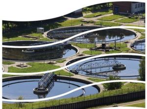
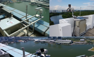
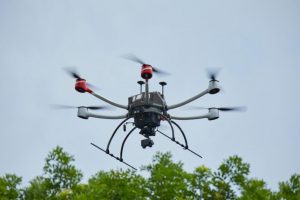
Water quality parameters in water bodies are usually obtained using in-situ sensor probes or by laboratory measurements of water samples collected on-site. These conventional methods are laborious, costly and have limited spatial coverage. This technology relates to a contactless measurement method for water quality parameters and can be deployed on buildings’ roof-top overseeing reservoirs or unmanned multi-rotor drones. This technology was developed to measure freshwater (reservoirs) parameters like Chlorophyll-a, water turbidity and CDOM (colored dissolved organic matter) but can be extended to detect surface scum, oil, and other contaminants. The principle and methods employed are similar to satellite imaging and the water body naturally illuminated by sunlight and can be measured based on water reflectance.
TECHNOLOGY FEATURES & SPECIFICATIONS
Remote sensing (non-contact) measurement has the advantage of low maintenance, avoids biofouling issues and regular calibration requirements compare to existing on-line water quality sensors. It also provides real-time measurement compare to lab-test and satellite spectral mapping of open water bodies. The flexibility of deployment, which could be deployed on fix locations like rooftop, fish farms or mounted on unmanned drone platform for customized mission/path planning.
Measurable water parameters:
- Water turbidity
- Chlorophyll-a (Chl-a)
- Colored Dissolved Organic Matter (CDOM)
- Oil contamination
- Surface scum
- Other contaminants
Specifications:
- Power: 20 – 24V D.C. or 240V A.C (fixed deployment) or Solar-powered
- Weight: Below 1.5Kg with full HSI configuration
The technology consists of 2 main components:
- Remote sensing algorithm that uses techniques similar to Satellite Spectral Imaging for monitoring water quality of open water bodies (ocean, lakes and reservoirs). It can be used to detect lake eutrophication, oil leaks and other water parameters.
- Sensors hardware and control systems with the flexibility of either Hyper Spectral Imaging (HSI) system for Area mapping configuration or Spot Sensing system for Point measurement configuration.
Versatile system deployment configurations:
- The first configuration includes a Hyper-Spectral Imager (HSI) which can capture an Area (Spatial) Image in a single snapshot for mapping the water quality distribution. This HSI configuration is designed for dense spatial measurement. HSI is a technology used in satellite remote-sensing applications such as forestry study and environment surveillance and can also be extended to industrial applications.
- The second configuration is a Spot measurement system, which has the advantage of compact system SWaP (Size Weight and Power) and more economical hardware cost. The second configuration is suitable for requirements that only need sparse (spatial scattered) multi-points measurement.
POTENTIAL APPLICATIONS
This technology can be applied to the following industries:
- Remote-Sensing of water quality monitoring (Sea and freshwater)
- Remote-Sensing applications such as forestry/crop study, environment measurement, minerals detection.
- Remote Gas and chemical detection
- Spectrum / Color analysis
- Forensic and spectral authenticity check
BENEFITS
- Addresses the industrial needs for the real-time mapping of water quality with relatively little maintenance.
- Cost-effective and responsive remote sensing system
- Deployed on-site or via UAV configuration
- Scalable for large-scale deployment